Espoo's 3D City Model Hackathon
- Pedro Aibéo
- Feb 5, 2016
- 10 min read
From 9th till 11th October 2015 the Energizing Urban Ecosystems[1] organized at the “Stage” in Aalto Design Factory, the first 3D City Model Hackathon of the city of Espoo focusing on how 3D City Models can serve as an innovation platform for Smart Cities.
Short video presentation of the whole event by
9th - 11th October 2015, Espoo, Finland http://3dcitymodelhackathon.com/
Live comments on the screen: http://presemo.aalto.fi/3dcityhack Facebook: 3D City Model Hackathon

The goal of the 3D City Model Hackathon was to create applications related to city planning, urban digitalization, living, traffic & transportation, energy and environment that utilizes the 3D City Model of Espoo and open data provided by the organizers. The open questions were:
How can the 3D City Model Serve as an Open Innovation Platform for Smart Cities?
How to Combine a 3D City Model with Real-time Energy, Traffic, or Mobile Phone Data?
How can 3D Gaming Technologies Utilize 3D City Models and Data from the Databases of the City?
How a 3D city model and Open Data are utilized to support University Campus and Otaniemi area restaurants, cafés, events, and facility management?
How can the Internet of Things Benefit from 3D City Model?
How to utilize Open Data and Open Interfaces In 3D City Models?
Fig. 1 The main stage of the event. Photo by Aibéo

The Hackathon offered a series of presentations from several companies, Institutions and Individuals who also mentored the participants during the three days. In-between, there was time for discussions, team building and to work. The participants had to apply for the hackathon via an online form and preference was given to software developers, designers and urban innovators with a desire to provide new services and applications to improve the living in the so strongly branded Smart Cities.
A series of APIs, software and 3D models were offered to the participants to hack upon. At the end, a total of 9 teams from over 70 participants came out with different proposals. These were offered several prizes for their work according to different categories.
The event was moderated by Pedro Aibéo who also belonged to the organizing team composed of himself, Jussi Lehtinen from Espoo City and Oskari Liukkonen from the company Sito.
The event was a collaboration between the Espoo City, Aalto University, Sito, Elisa, IBM, Slush, Futurice, Colossal Order, Unity, Tietoa, Fira, Virtual City Systems, AEC Hackathon Helsinki, Helsinki City, Gispo, Architectural Democracy, VTT (Technical Research Centre of Finland) and Kone
Fig. 2 The participant's tags. Photo by Viitanen Maria


Event's schedule
Friday, October 9th 16:00 Registration, snacks and coffee and Kick off 16:30 Welcoming Speeches 16:30 Tuula Antola, Director of Economic and Business Development, Espoo 16:40 Jarmo Suomisto, 3D City Model Project Manager, Helsinki 16:50 Satu Kankaala, Aalto University Campus & Real Estate 17:00 Speed networking and grouping 17:30 Company presentations 17:30 Futurice 17:40 Elisa 17:50 Fira 18:00 IBM 18:10 Kone 18:30 Grouping continues (if needed) 20:00 Dinner
Saturday, October 10th 09:00 Kick off with breakfast 09:30 Company presentations 09:30 Tietoa 09:40 Virtual City Systems 09:50 Pekka Sarkola, Gispo 10:00 Janne Porkka, VTT 12:00 Lunch 13:00 Company presentations 13:00 Sito – 3D City Models & Unity 13:10 Pedro Aibéo – Architectural Democracy 17:00 Snack 20:00 Dinner
Sunday, October 11th 09:00 Kick off with breakfast 12:00 Lunch 14:00 Presentations 16:00 Discussion & Awards 17:00 THE END
GUEST SPEAKERS
The organizing team’s criteria for the invited speakers was to have both back-end and user interface experts coming from private companies, research institutions and governance.
1st Speaker:
Tuula Antola
Director of Economic and Business Development
City of Espoo.

Fig. 3 Tuula Antola at the Hackatthon : Snapshot from the video streaming
”Please help provide us with some good ideas. If they will be good, maybe we will implement them. But if they will be something superb, definitely we will implement them”
2nd Speaker:
Jarmo Suomisto
3D City Model Project Manager
City of Helsinki
„People who are making 3D city models, 3D semantic models in Finland it’s such a small group, it’s like a family it’s like a thing we had in the 90s when we were doing GIS work or CAD (...) We have few people here in Finland so if we do it separately the same things it doesn’t work at all.”
3rd Speaker:
Satu Kankaala
Aalto University Campus & Real Estate
ACRE
"The goal is for Otaniemi is to be energy self-sufficient"
4th Speaker:
Paul Houghton
Director, Wizardry and Development
Futurice

„What we are talking about for openness is that businesses and the city and users can put their data together so that you have very low friction among them for adding a new service"
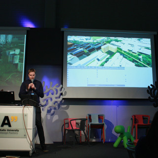
Fig. 4 Paul Houghton's presentation. Photo by Aibéo
5th Speaker:
Aimo Maanavilja & Jyri Kosonen
Elisa
"About our Elisa Hackathon challenge for you: How to engage citizens to participate in city development?"
6th Speaker:
Mikael Långström
Fira
A construction company building in Jatkäsäri in August 2016. Mikael offers a set of data that might inspire some of the „Hackers“: „We have temperature data of all the individual apartments in that data model, that’s about it. We hope you can use this information somehow and let’s see what you guys come up with.“
7th Speaker:
Arto Ahde
IBM
Against the usual believe that big companies move slowly, IBM is putting up digital platforms such as the Bluemix: „What I am presenting today is the IBM Bluemix, which is the platform as a service which is the offering that we have, and it is more than that, it is more like a digital innovation platform.“
8th Speaker:
Jaakko Hauro
Tietoa
„How 3D city models, how they’ve been before and become open and usable for general public.“
9th Speaker:
Lucas van Walstijn
Virtual City Systems
"We create high performance web visualization of city models"
10th Speaker:
Pekka Sarkola
Gispo

„You don’t want to limit your possibilities or your ways or ideas to go into the proprietary closed up source data, API’s Standards or whatever“
Fig. 5 Pekka Sarkola at the main stage. Photo by Viitanen Maria
11th Speaker:
Janne Porkka
VTT
"Less time for introduction, more discussion!"
12th Speaker:
Andrzej Skibiński
3D City Models & Unity
"Our user cases are, costum solutions, avatars, spatial engines"
13th Speaker:

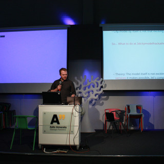
"Complexity, City, 3D Model, if we are to empower citizens to add information to it, we have to give away for them to understand it in a fast and easy way and to empower, to edit it, if they don’t understand it, they will never do it"
Fig. 6 Pedro Aibéo on the main stage. Snapshot of the live straming
FINAL PRESENTATIONS
Over 70 participants took part on the Hackathon. At the end we had 9 presentations of their joint work. These were given different prizes according to its scope.

Group 1:
ESTIA, SPIRIT OF OUR BUILDINGS
Fig. 7: Group 1. Photo by Viitanen Maria
Team members:
Taha Kachwala taha.kachwala@aalto.fi Full-stack developer
Thuy Nguyen thuy.4.nguyen@aalto.fi UX, Front-end developer
Cillian Warfield cillianwarfield@gmail.com Architectural concept
Janne Salo janne.h.salo@aalto.fi Architectural concept
Kiki Christaki kyriaki.christaki@aalto.fi Graphics designer
Maria Gaci maria.gaci@aalto.fi Graphics designer
Summary: Estia group developed a data-driven adaptive lighting and way finding system that promotes space sharing for energy saving and also allows the building to communicate with people through lighting and multiple devices.
They started this Hackathon by thinking about how buildings communicate with people. How can all the data of buildings such as heating, electricity usage, water usage, and occupancy be effectively communicated to the people who are using the building.
The whole concept was to avoid buildings where one receives the information through smartphones but to have a system that integrates the information with the actual interior design and the architecture of the building.
At the back end there is an analytic model of energy data to visualize such data in a deeper way for people to understand how they use their energy.
Full presentation here: https://youtu.be/IXumMGZvTeM

Group 2:
PLAN P : PLAY A PLANNER WITH GEOGRAPHIC INFORMATION
Fig. 8: Group 2. Photo by Viitanen Maria
Team members: Helena Iltanen helena.iltanen@aalto.fi
Petri Kangassalo petri.kangassalo@aalto.fi
Frank Müller frank.muller@aalto.fi
Marc Summen marc.summen@aalto.fi
Summary:
Plan P group proposed a fast and easy-to-use urban planning tool that compares and analyzes relevant information. It enables one to see the impact of new buildings and play around with ideas. It is aimed for city planners, decision-makers, activists, and citizens.
The problems the team wanted to solve were:
- planning new buildings is complicated
- it is not easy to take certain aspects into consideration
- the impact of a (new) building is hard to predict
- data is often distributed on several Platforms/Programs
- data is often only visible in 2D
The idea, one tool to (rule them all):
- plan new buildings
- get information about the impact of buildings
- combine all the available information
- virtualize buildings and their environment
- see the 3D buildings and the 2D information at one glance
With Plan-P You can...
… look at the 3D model of Otaniemi
… look at various data presented in colors on the map
… add new buildings to the model trying to achieve planned targets, for example certain square meter amount
… analyse the impact of (new) buildings
… analyse the impact of environment/climate change
More about Plan-P: http://abe.aalto.fi/en/researchprojects/plan-p/index/
Full presentation here: https://youtu.be/9DjGy-EQGNo

Group 3:
VISUALISATION SOLUTION OF THE CONSTRUCTION INDUSTRY
Fig. 9: Group 3. Photo by Viitanen Maria
Team members:
Samuli Kuusisto samuli.kuusisto@stereoscape.com
Summary:
Samuli Kuusisto represented Stereoscape Oy, a Finnish company that uses interactive 3D animation, virtual reality and other tools of the digital age to deliver high-impact product visualizations for marketing, sales, training and other applications. The demo is an early phase of a solution that delivers a sort of interactive BIM model for the construction industry to pre-market apartments and buildings. It was made with Unity 5.2 using pre-existing 3d model of Otaniemi area provided by the 3d City Model Hackathon.
The user can zoom in multiple ways, rotate around the target (pre-selected building), control the time-of-day and cloudiness, hide and show a building façade, choose a stair, room count and floor of the building and when pressing ‘select’ button the code shows the available apartments in the building according to the user’s selection. The visualization is created by manipulating cost-effectively pre-existing CAD- and IFC-models. The visualization is upgradeable, and it can be made use of in various contexts, for example in different phases of a building project and in diverse marketing channels.
Full presentation here: https://youtu.be/HdQ4mcd4UAQ

Group 4:
REALTIME VOICE RECOGNITION BASED NAVIGATION OF ESPOO-HELSINKI METROPOLITAN AREA ON UNITY 5
Fig. 10: Group 4. Photo by Viitanen Maria
Team members:
Antti Hietaniemi antti@beigeharmaa.com Olga Kornilova Mikko Mutanen mikko.mutanen@fjordnet.com
Summary:
Representing their own company, Beigeharmaa which does real-time visualization and motion graphics, they used the three hackathon days to implement their real-time voice recognition based navigation which runs on unity 5, into the 3D city model of Espoo. The Espoo city data model that they received from this Hackathon has a much higher level of detail than the Helsinki one they worked before. In the presentation they showed the real time demo by using its voice controls.
A draft version of the project can be found at the GitHub repository:
https://github.com/Beigeharmaa/bh-hki-espoo-map
You can find the voice recognition by Api.ai Unity implementation based on api.ai Sample Unity app at:
https://github.com/api-ai/api-ai-unity-sample
Full presentation here: https://youtu.be/exkF7svT6Ws

Group 5:
LIVE TWEETS
Fig. 11: Group 5. Photo by Viitanen Maria
Team members:
Santeri Nuotio jason.nuotio@aalto.fi
Erika Salmivaara erika.salmivaara@sito.fi
Summary:
This application developed along these 3 days by these 2 individuals had, in contrary to other groups, no backing from previous ongoing projects. The main idea was to access tweets (for the experiment sake, the 3D City Hack Tag were used) and with it, one could see the activity of events geo located. This was shown via a tweet logo on the building of the design factory. One thus knows that there is a gathering of people in that location and anyone can click on such logo to access all the live tweets. The idea of getting people’s location to optimize services is a current one that clashes with the desire of many to keep some features private. Some of the Q&A focused on that point in which the group replied as this not having been designed as a consumer product.
Full presentation here: https://youtu.be/k7QfyyNk2pU

Group 6:
BRAINSTRÖM, REPLACING 3D PRINTED MODELS WITH REALISTIC IMAGES IN AN AUGMENTED REALITY APPLICATION
Fig. 12: Group 6. Photo by Viitanen Maria
Team members:
Petri Saarinen, petri@teraloop.org
Santosh Mehta, santosh.mehta@student.hamk.fi
Petri Heino, petri.mehta@student.hamk.fi
Juha Järvi, befunge@gmail.com
Leo Salomaa, salomaa.leo@gmail.com
Heikki Heiskanen, heikki.j.heiskanen@aalto.fi
Lu Xuanbei, xuanbei.lu@aalto.fi
Summary:
The problem the group tackled was that when one is designing cities one often makes miniatures out of them but there is still quite a gap between the virtual model and the physical model. It was thus intended to make an augmented reality application that would function as a bridge between these two. Basically the functionality is that you can put different textures in the models and by scrolling on a bar you can see how in a few years’ time the materials will look like in the real world.
Full presentation here: https://youtu.be/t0QCgfhSNOg

Group 7:
AHYE, INDOOR ENVIRONMENT MONITORING SYSTEM
Fig. 13: Group 7. Photo by Viitanen Maria
Team members:
Ye Huang ye.huang@aalto.fi
Seamule Hyttinen samuli.hyttinen@aalto.fi
Jin Jin jin.jin@aalto.fi
Umit Dost umit.dost@aalto.fi
Shan Zhong shan.zhong@aalto.fi
Summary: Being developers, this team tackled data collection. They developed during these days, a tool for real time data monitoring of the buildings of Otaniemi by simply clicking on them on the 3D map.
Demo and Source are available here:
• Project: http://3dcity.firebaseapp.com
• Source: https://github.com/crabcanon/3d-citymodel
Full presentation here: https://youtu.be/StPjixjgUK0
Group 8:

OTAMAP
Fig. 14: Group 8. Photo by Viitanen Maria
Team members:
Matti Parkkila UE4 coordinator / team manager matti.parkkila@aalto.fi +358 45 1389151
Aleksi Ala-Harja Manual data harvesting aleksi.ala-harja@aalto.fi +358 44 3001226
Aleksi Jokela UE4 / programming aleksi.o.jokela@aalto.fi
Väinö Yrjänäinen 3D modelling / animation vaino.yrjanainen@aalto.fi
Juha Koivusalo UI / graphic design www.juhakoivusalo.com
Summary: The basic idea is that when one doesn’t know where classrooms are one can turn on the application, one inputs where you are and where you want to go and then you can see a 3D model that takes you to the location, including indoor navigation.
Full presentation here: https://youtu.be/SHWyTI876Gk

Group 9:
3D CITY MODEL USERS ANONYMOUS
Fig. 15: Group 9. Photo by Viitanen Maria
Team members:
Antti Kauppi
Summary:
Maps in itself are not that exciting, one needs to build services on it to make it exciting. This team proposed and partially implemented geo-referenced and virtual reality information into digital maps by using a different set of sensors of smartphones.
Full presentations here: https://youtu.be/Qkp4pknbuGo http://prezi.com/g-xcpbnzprwr/?utm_campaign=share&utm_medium=copy
CONCLUSION
Hackathons are important alternative tools within our ever changing teaching and collaborative system. One designates time to focus solely on one project (instead of the daily multi-tasking), most commonly for a few days around a problem or a challenge based on software. It is a collaborative environment to turn ideas into reality.
Often so, such events are used by companies or individuals to develop their ideas further and pitch them. But there are also individuals who are teaming up and from scratch, they bring about new solutions. Such shows one of the big qualities of Hackathons, its flexibility.
The promoters of this event understood that there is a high number of engaged people who have plenty of ideas and knowledge on the topic of smart cities, who are eager to collaborate with larger projects and institutions. These events are both solution generators and networking enablers and promote a spirit of collaboration and openness. The event served this purpose fully and ought to be be repeated within similar formats.
FURTHER PHOTOS


[1] (EUE, a project that focuses on developing new business models for Smart Cities)
---
Report writen by Pedro Aibéo
Pedro Aibéo is a trained Design Architect (M.Sc., Dipl. Ing., TU Darmstadt, Germany) and Civil Engineer (M.Sc., Licenciatura, FEUP, Porto) with over 50 buildings built on 15 countries. He is also a Visiting Associate Professor at UNAM University, Mexico and at Wuhan University of Technology, China, and a Lecturer, Research Assistant and Doctoral Candidate at Aalto University, Finland on "Architectural Democracy". He is the founder and Artistic Director of “Cidadania” theatre+games group, Germany, with written and directed theater plays at the United Nations and the Staatstheater Darmstadt on urban slavery and astronomy. He is a professional Musician at "Homebound" and the founder and Artistic Director of the "World Music School”. He is a drawing teacher at the croquis nights in Helsinki and a comic novel writer on mathematics. He is a published current affairs author in several newspapers.
City modeling hackathons, like Espoo’s 3D initiative, challenge participants to create detailed, interactive urban layouts in compressed timeframes. These events foster collaboration, problem-solving, and practical applications of spatial thinking. To bring similar concepts into your own projects, https://www.gambody.com/stock offers high-poly STL files that allow makers to produce miniature cityscapes or architectural elements. 3D printing these designs transforms abstract planning into concrete, manipulable objects, giving participants an enhanced understanding of scale, layout, and urban complexity.